

The NBC10 First Alert Weather Team is tracking a winter storm expected to arrive as early as Sunday evening that could linger into Tuesday morning. The storm is expected to pack snow but also pockets of sleet and freezing rain in some neighborhoods.
A First Alert is in effect for the entire greater Philadelphia region, meaning people should take the time to prepare now so they’re not caught off-guard. Even before the snow arrives, conditions will feel pretty brutal. Winds will gust between 40 and 55 mph at the Jersey Shore and 35 to 45 mph inland, making temperatures feel like they’re in the teens.
Winter storm warnings have been issued in the following counties in Pennsylvania: Bucks, Berks, Chester, Delaware, Montgomery, Philadelphia, Lehigh, Northampton and Cumberland. We also see winter storm warnings in New Castle County, DE, and Burlington, Camden, Gloucester, Mercer, Salem and Hunterdon counties in NJ. Ocean, Burlington, Cape May and Atlantic counties in NJ are on a coastal flood watch.
We are answering some of your questions with what we know at this point. Make sure to check back, as the forecast may adjust when information becomes more clear.
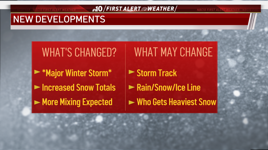
A major winter storm is headed to our region, and we updated our forecast with increased snow totals and a higher chance of wintry mix. The storm track and the rain/snow/ice line, along with where the heaviest snow could fall, could still change.
When Is the Snow Expected to Start? How Long Will It Last?
Light-to-steady snow is expected to arrive Sunday evening, though the heaviest amounts will fall on Monday.
Sunday night into Monday morning, we could see a lull with only light snow, or sleet and light freezing rain.
Mid-day Monday into Monday night, we'll see precipitation pick back up and change to steady, heavy snow making for pool travel conditions.
Rock salt was also a hot item as a two-part winter storm approached and residents in our area prepared. NBC10's Drew Smith reports.
Things should move out by Tuesday morning.
With the ground cold, any snow that falls will start to stick to untreated surfaces. Driving will be slippery, and it’s advised people avoid driving altogether on Monday. Even by Tuesday morning, it’ll be best to wait for the snow plows to do their work before hitting the road.
What Should You Expect From the Winter Storm?
You should expect snow, enough to need plowing, and rain or a wintry mix down the Jersey Shore and in southern Delaware. Inland areas are expected to get the biggest snow totals.
People at the Shore and in southern Delaware might get rain or a mix of freezing rain and sleet Monday morning. However, there could still be 1-3 inches of snow near the beaches and 3-6 inches further inland.
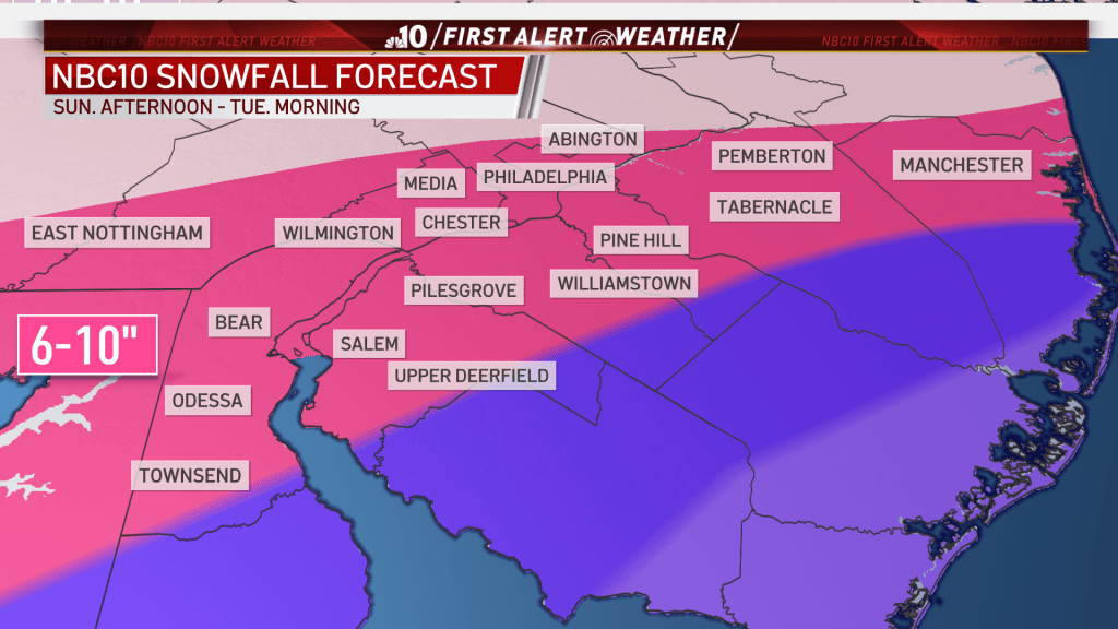
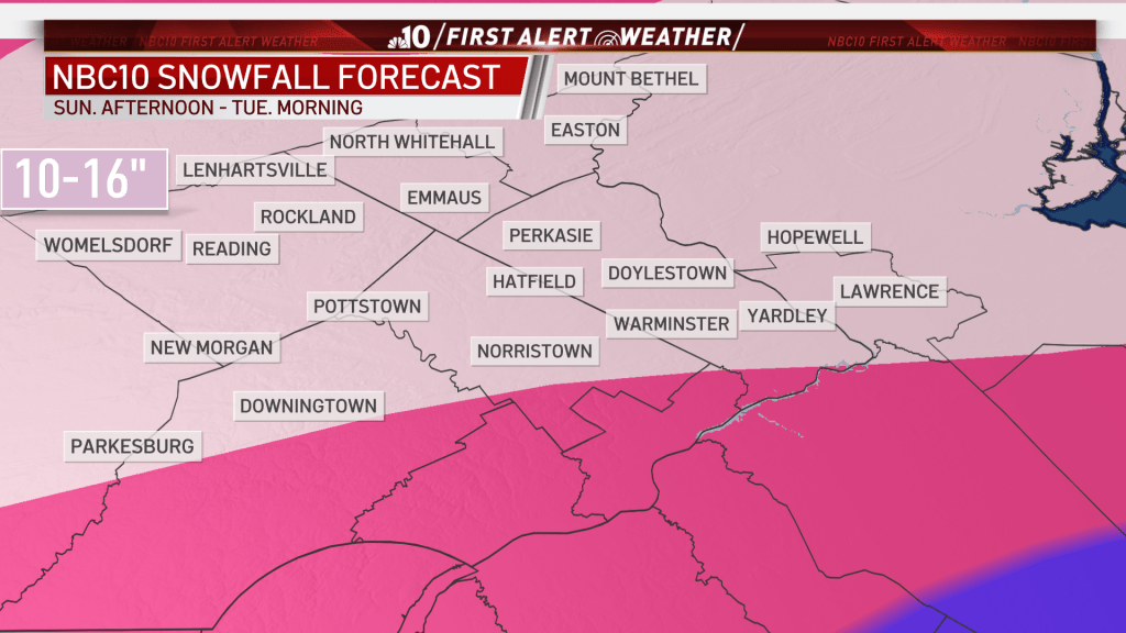
North of those areas, people should brace for anywhere from 6 to 10 inches, or as much as 16, depending on where they live.
Will It Be Snow, Ice or a Mix Where I Live?
The forecast becomes more challenging on Monday as snow is expected to mix with sleet and freezing rain in some neighborhoods. That will lower the potential snowfall totals in those areas but could add to concerns over slippery travel and potential power outages.
A difference of a degree or two could change snow to ice. Winds which could gust over 50 mph near the coast could add to the threat for the lights going out.
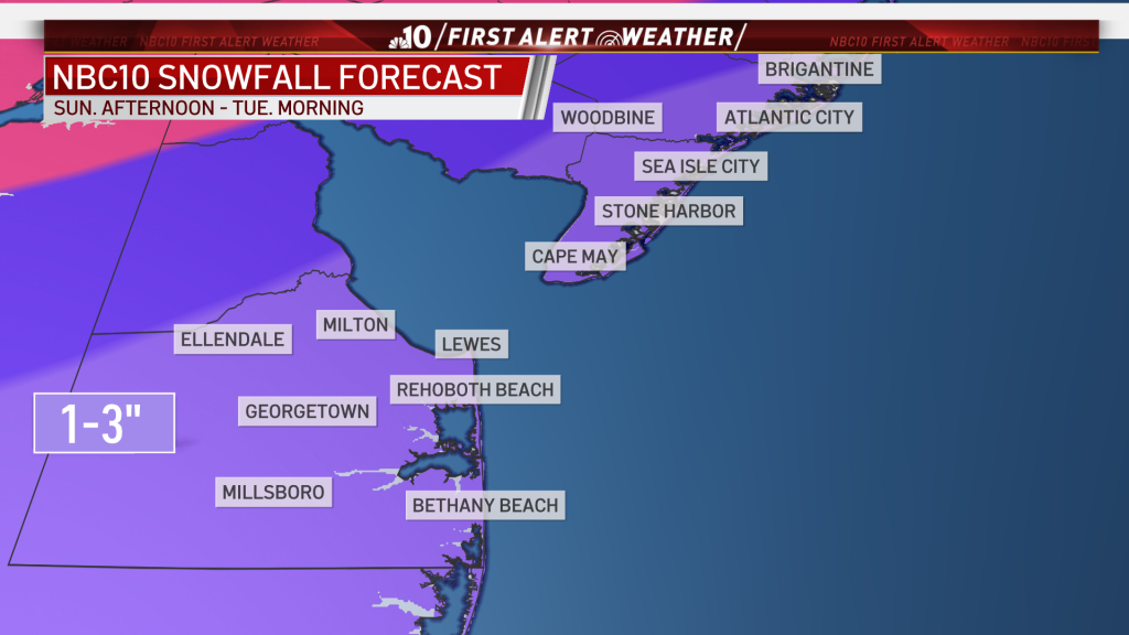
By Monday morning, the Jersey Shore and southern Delaware might see rain or a mix of sleet and freezing rain. As the day progresses, 3 to 6 inches of snow could fall in inland South Jersey, though neighborhoods closer to the beach may only get 1 to 3 inches.

Inland is where most of the snow is expected to fall. Neighborhoods from the I-95 corridor and northward could get 6 to 10 inches. We could see 10 to 16 inches north of the Pennsylvania Turnpike.
What Changes Should I Look Out for?
Our team is working to determine where the heaviest snow and sleet will be during the second part of this storm. We also are still trying to answer how much of the precipitation will be snow, and how much will be a wintry mix.
It is important to stick with the NBC10 Weather Team's latest forecast as the track could continue to shift.
A shift in track could mean a change in what Philadelphia area neighborhoods get the heaviest and most intense snowfall before the storm moves out Tuesday morning.
Stay Ahead of the Storm
Download the NBC10 app right now and continue to tune into NBC10 News on air, on Roku and on Apple TV as the First Alert Weather Team continues to update the storm forecast throughout the weekend.
"will" - Google News
January 31, 2021 at 04:57AM
https://ift.tt/2YxtLwV
First Alert: How Much Snow Could Fall Where You Live? - NBC 10 Philadelphia
"will" - Google News
https://ift.tt/2xyU8J2
https://ift.tt/2zfWs7Z
Bagikan Berita Ini


0 Response to "First Alert: How Much Snow Could Fall Where You Live? - NBC 10 Philadelphia"
Post a Comment